The geography of Kashmir essentially boils down to mountains and water. In spiritual tradition the Himalayas are the home of the Gods and cosmic creation is part of the Himalayan religious tradition. Around 80 million years ago, the land mass which is now India broke away from Gondwanaland and ventured north to marry Asia in a ceremony which birthed the highest and most sublime mountain range on earth, the Himalayas. Mt Kailash in Tibet is worshipped as the most sacred mountain of the Himalayan range, the home of Lord Shiva and the spiritual
centre of the universe. Kailasa is poeticized as being the best place in the three worlds, the best place in Kailasa, the Himalaya and in the Himalaya, Kashmir. The main Himalayan range is the principal range that divides the Indian subcontinent from the Tibetan plateau. From Nanga Parbat in the west, the range stretches for over 2000km to the mountains bordering Sikkim and Bhutan in the east. The West Himalaya is the range that divides Kashmir from Himachal Pradesh and Ladakh.
Politically Kashmir is located in the North West of India – the ‘head’. Roughly bordering the west
and the north of Jammu and Kashmir is the Line of Control (LoC). The LoC is the militarized demarcated borderland between India and Pakistan. To the east of of the Kashmir valley is the Zoji-La (3850m) which leads you through Kargil and into Ladakh. East of Ladakh is the Aksai Chin, the border India shares with China. Located in this area is also the region’s biggest glacier, the Siachen glacier, which is known as the world’s highest, costliest and coldest battlefield! The Siachen glacier is also reported to have been reduced by half in the 25 year that Pakistani and Indian troops have been stationed there in a wintery attempt to patrol their soluble borders.
Located in Kashmir are 60 of the 327 major Himalayan glaciers, contributing to 75% of the water in the Indus Water Basin. The glaciers of Kashmir majorly contribute to sustenance of life and agriculture in the region and into the Indian planes. Kashmir’s Kolohai glacier is one of the largest glaciers of Kashmir and a major source of water for south Kashmir. Due to the unprecedented shrinking of the glaciers in Kashmir, there remains tension over the future of agriculture in both India and Pakistan, access to clean and necessary drinking water for both populations and also who has rights to what water in regard to Pakistan and India’s ‘Indus Water Treaty’ of 1960.
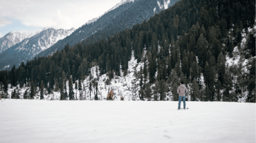
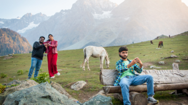
The Kashmir Valley is an ancient lake basin 140km long and 32km wide, the average elevation is 5300ft above sea level. The mighty mountains of the Western Himalaya that surround the Valley rise in some places to 16000ft. To the south of the main Himalaya and of the Kashmir Valley lies the Pir Panjal range (average elevation 5000ft).
It is through these mountains you travel when starting from Jammu. To enter into the valley, you must cross the Banihal pass, it is here the that Pir Panjal meets the ridge line which separates the Kashmir Valley from the Warvan Valley of Kishtwar. Before the political creation of Jammu and Kashmir, geographically Kashmir indicated the area between the Pir Panjal and the Greater Himalaya.
Kashmir has three major rivers. The Indus River and its tributaries provide the principal drainage system in the Western Himalaya. Other rivers are the Chenab and the Jhelum – considered the blood of Kashmir.
Comment (0)