About Kashmir, India by Ahanger HOBO.
The Kashmir primarily comprises mountains and water bodies. In the spiritual context, the Himalayas are considered to be the abode of Gods, and its religious traditions involve cosmic creation.
It was a time before 80M years ago, at that time the Indian subcontinent breaks up into parts from Gondwanaland and drifts northward to merge with Asia and emerge in the formation of the world’s highest mountain range, the Great Himalayan Range. Tibet’s Mt. Kailash is worshipped as the holiest mountain in the Himalayan range, representing Lord Shiva’s abode and the spiritual center of the universe. As per some sayings Kailasa is believed to be the best place in the three worlds, the Himalayas, and Kashmir Valley. The Indian subcontinent is broken up from the Tibetan plateau by the main Himalayan range, which stretches for over 2000km from Nanga Parbat (Nanga Parbat is considered one of the most difficult and dangerous, for Climbing in History. Worlds in the west to the mountains that border Sikkim and Bhutan in the east.
A Little over about Ahanger HOBO Ahanger HOBO has actual history and the best knowledge about Kashmir, not only that but gives you “the best hotel accommodation”. Ahanger HOBO always believes in the best services.
East of Ladakh is Aksai Chin, the border India shares with China, and the site of the region’s biggest glacier, the Siachen glacier, considered the world’s highest, costliest, and coldest battlefield. Sixty of the 327 major Himalayan glaciers is located in Kashmir, which contributes to 75% of the water in the Indus Water Basin, crucial for sustaining life and agriculture in the region and the Indian planes.
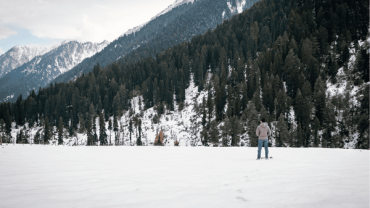
The Kolohai glacier in Kashmir is among the largest and most vital sources of water for southern Kashmir. The Kashmir Valley is an ancient lake basin spanning 140 km in length and 32 km in width, with an average elevation of 5300ft above sea level. The mighty Western Himalayan mountains surrounding the Valley rise up to 16000ft in some places. To the south of the main Himalaya and the Kashmir Valley lies the Pir Panjal range, with an average elevation of 5000ft.
To enter the valley, one must cross the Banihal pass, where Pir Panjal meets the ridge line separating the Kashmir Valley from the Warvan Valley of Kishtwar. Geographically, Kashmir referred to the area between the Pir Panjal and the Greater Himalayas before Jammu and Kashmir’s political creation. The region is home to three major rivers, namely the Indus, Chenab, and Jhelum, with their tributaries forming the principal drainage system in the Western Himalaya, and the latter two are revered as the lifelines of Kashmir.
Coordinates: 33°5′24″N 74°47′24″E
Administering state: India
Capitals: Srinagar (May–October); Jammu (November–April)
Districts: 20
HDI (2018): 0.688 (Medium)
Highest elevation (Nun Peak): 7,135 m (23,409 ft)
ISO 3166 code: IN-JK
Union territory: 31 October 2019
“Ahanger HOBO offers Accommodation | Transportation | Adventure| Sxr Airport Services | Taxi throughout Kashmir Valley.”
Comment (0)